GNSS combined with RTK is a solution that can realize real-time precise positioning, and the positioning accuracy reaches centimeter level. It is widely used in application scenarios that require high-precision positioning. GPS as a kind of GNSS, people often use RTK GPS technology to refer to RTK GNSS technology.
What is GNSS?
GNSS, short for Global Navigation Satellite System, is a space-based radio positioning system that consists of one or more constellations of satellites. It refers broadly to all satellite navigation systems including global, regional and augmented.
GNSS provides Positioning, Navigation and Timing (PNT) information signals from space for global or regional users. Satellites in space transmit information to GNSS receivers on Earth. This information is then used to determine position.
What is Difference Between GNSS and GPS?
 GPS is a type of GNSS. There are 4 kinds of fully operational GNSS in the world: GPS, GLONASS, Galileo, BeiDou.
| System | GPS | BeiDou / BDS | Galileo | GLONASS |
| Owner | United States | China | European Union | Russia |
| Coding | CDMA | CDMA | CDMA | FDMA & CDMA |
| Precision | 0.3–5 m | 3.6 m | 1 m | 2–4 m |
In addition to this, there are regional navigation systems such as NavIC (IRNSS) in India and QZSS in Japan.
How Does a GNSS System Work?
GNSS consist of three major segments: the space segment (satellites), the control segment and the user segment (GNSS or GPS receivers).
Space Segment

The space segment is composed of satellites. Each satellite in the GNSS constellation broadcasts a signal that provides information about its time, orbit and status. The specific functions are:
1. Receiving and storing navigation information sent by ground monitoring station; receiving and executing control instructions of monitoring station;
2. Provide precise time standards through space-borne high-precision cesium clock and rubidium clock;
3. Send location information to users in real time;
4. Under the command of the ground monitoring station, adjusting the attitude of the satellite and activating the standby satellite through thrusters;
5. There is a microprocessor on the satellite to perform some necessary information processing work.
Control Segment
The control segment is a ground network composed of a main control station, information upload station, monitoring station. The specific functions are:
1. Tracking, observing, collecting information, calculating the orbital parameters, clock parameters of each satellite and the correction parameters and clock parameters of the atmosphere.
2. Adjusting satellites that deviate from their orbits and activating backup satellites when necessary.
3. Coordinating and managing the work of all ground monitoring systems; providing time reference.
User Segment
The user segment refers to the GNSS receiver. GNSS receivers have two parts: the antenna and the processor. The antenna is used to receive satellite signals, and the processor is used to decode the satellite information into commonly used measurements such as latitude and longitude.
What is GNSS used for?
Currently, GNSS is used in a variety of fields that require precise, continuously available information about location and time. These fields include agriculture, transportation, machine control, ship navigation, vehicle navigation, mobile communications, and sports.
GNSS technology enables businesses across our market to optimize the efficiency of materials and operating costs, and to provide a range of additional benefits from environmental concerns to workforce safety.
What is RTK?

RTK (Real-time kinematic positioning) is a technology used to improve the accuracy of GNSS positioning. GNSS receivers measure the time it takes for a signal to travel from the satellite to the receiver. The transmitted signal travels through the ionosphere and atmosphere, slowing down and perturbing along the way. Because of that, the GNSS receiver can only calculate and determined the position with low accuracy of 2-4 meters.
RTK solves this problem. It can provide users with centimeter accuracy of up to 2cm for applications that require greater precision.
RTK Type
RTK correction signals are divided into two types, radio RTK signals from fixed base stations and network RTK signals from internet.
Fixed Base Station
The base station is placed at a point with known coordinates (datum or pre-measured point). It sends correction signals to the GNSS receiver. Moreover, it uses sophisticated statistical methods to adjust the phase of these signals and improve the position accuracy to ≤2 cm.
NTRIP
This approach requires a stable Internet connection and a subscription to a local NTRIP service provider that has a fixed base station infrastructure for a national or regional network. The NTRIP service provider can calculate the correction information based on the information from the nearby base station and return it to the GNSS receiver.

One of the main advantages of NTRIP is that it uses a network of RTK base stations that are already very well deployed and therefore have no range limitations. This is ideal for open road testing where a single fixed base station is more than 10 km away. But if network signals are poor or NTRIP service providers are not available, fixed base stations are essential.
What is RTK used for?
Any application requiring centimeter-level accuracy is likely to benefit from RTK technology, including mapping, precision agriculture, robotics and automation, mining, automotive, maritime, rail, and aerospace (UAS) industries.
FJDynamics Related Product
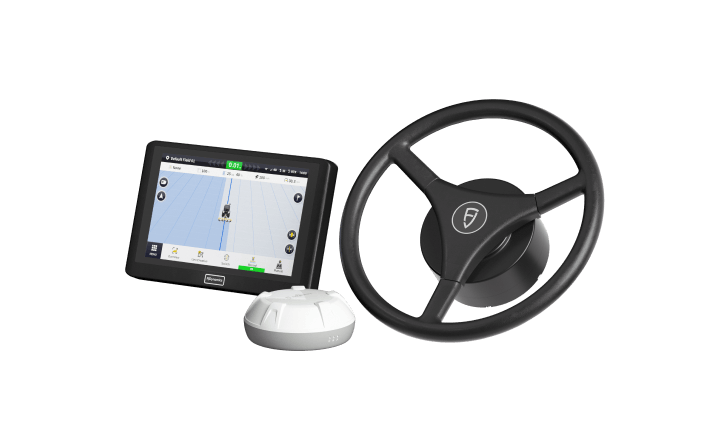
FJD AT2 Auto Steer System
FJD AT2 Auto Steer System combines GNSS and RTK to guarantee a 2.5cm pass-to-pass accuracy on any terrain.
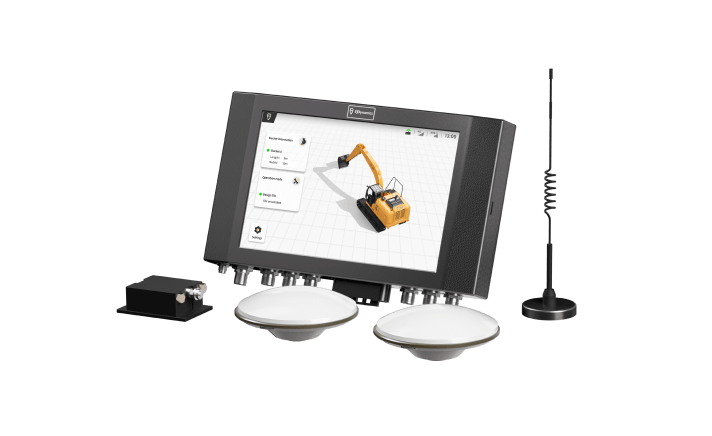
FJD G31 3D Excavator Guidance System
3D excavator grade control guidance system uses GNSS+RTK technology to achieve 3cm digging accuracy, applied in digital construction.
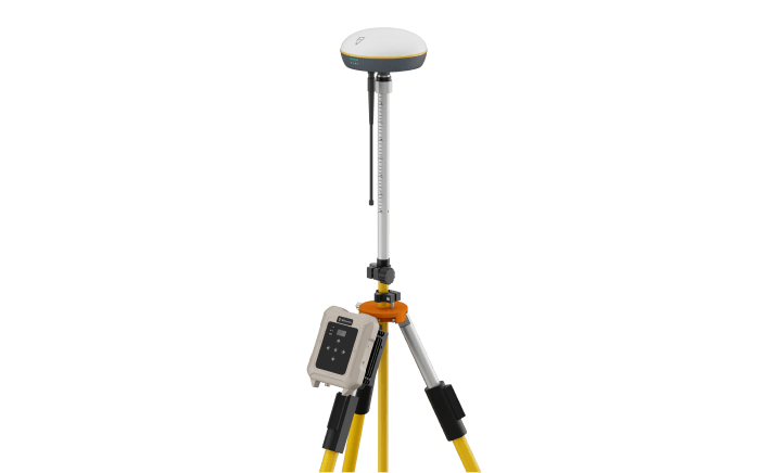
FJD V1 Base Station
FJD RTK base station is used to provide radio RTK signal.
References
1. Bernhard Hofmann-Wellenhof, Herbert Lichtenegger, Elmar Wasle, "GNSS — Global Navigation Satellite Systems", springer.com.
2. Paolo Dabove, Mattia De Agostino and Ambrogio Manzino, "Achievable Positioning Accuracies in a Network of GNSS Reference Stations"", intechopen.com.
3. "Other Global Navigation Satellite Systems (GNSS)", gps.gov.
4. "Satellite Navigation" , wikipedia.org.
5. Ahmed El-Mowafy,Curtin University, Australia, "Precise Real-Time PositioningUsing Network RTK", intechopen.com.