We're launching #FJDTrion Reality-Capture Stories, and we want YOU to share how the FJD Trion scanner or software powers your work!

Your story could win top-tier prizes and inspire professionals worldwide!

Scan, Share, Win: Your 3-Step Guide

🎥 Submit a video showcasing how you use the FJD Trion S1/P1/S2, Scan or Model.

💡 Be creative! From device setup to point cloud magic — we want to see it all.
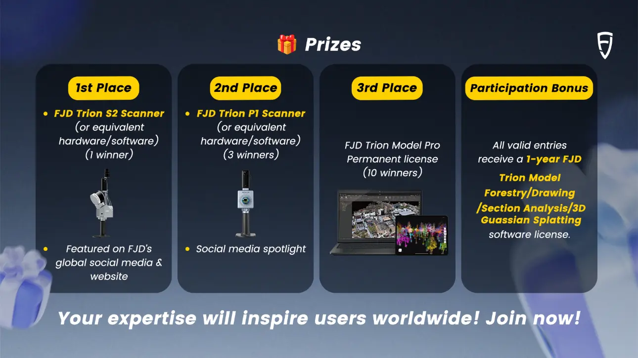
🏆 Exciting prizes!

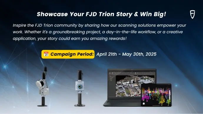
Campaign Period: April 21 -May 30, 2025

If you don't have one but would like to use the FJD Trion product for this activity, please leave your contact information. Our distributors will get in touch with you as soon as possible.

Leave your contact information 


Case Requirements

Product Visibility

▸  Clearly feature FJD Trion Scanner (S1/P1/S2) or software (FJD Trion Scan or FJD Trion MODEL) in your submission.

Creative Freedom

▸  Showcase any scenario: device installation, data capture, point cloud processing, team collaboration, client interviews, or innovative use cases.

Video Rules

▸ At least 30 seconds long (landscape orientation preferred)
▸ Ensure high-quality visuals and audio (Keep the camera steady, no shaky videos)
▸ Original videos only (no subtitles). Content must be original and unpublished. Avoid copyrighted music or third-party material.


Participation Rules

Submission Guidelines

▸ Post your video to a public platform (YouTube, Facebook, LinkedIn etc.) with hashtags: #FJDynamics #FJD Trion and tag at FJD Trion
▸ Share the video download link via email to geo.mkt@fjdynamics.com. Include a brief description explaining your project/scenario.
▸ Join our professional community:FJD Geospatial Communityand share your video link (You can also gain more votes by showcasing in the community.)


How to get FJD Trion product?

▸ Join FJD Geospatial Community to get a 30-day FREE license for FJD Trion Model and download it.
▸ If you don't have one but would like to use the FJD Trion product for this activity, please leave your contact information. Our distributors will get in touch with you as soon as possible.

Deadline

▸ Submissions close on 21st May, 2025


vids

FJD AL01 3D Land Leveling System uses GNSS RTK high-precision positioning technology to provide a comprehensive solution for farmland leveling. This GPS land leveling system can optimize water management, improve productivity, and increase yields.
 
01. Ali Qapu Scanned with FJD Trion P1 – Light Meets Legacy
Using the Trion P1 SLAM LiDAR, the 400-year-old Ali Qapu Palace was digitally captured to support non-invasive inspection and long-term restoration planning.
 

02Construction & Facility Scanning Made Easy with FJD Trion P1

On construction sites and in facility management, Trion P1 enables fast scanning and visualization, streamlining workflows and boosting operational efficiency.
 

03. FJD Trion P1 × Residential Landscape Remodeling | One Walk, High-Quality Point Cloud

Using the Trion P1 SLAM scanner, a single site walk efficiently captured terrain, structures, and vegetation, delivering clean point cloud data for predesign and landscape remodeling.
 

04. FJD Trion S1 Rapid Scan of 2500㎡ Office Space

This video demonstrates how the FJD Trion S1 scanned approximately 2500㎡ of office space in just 90 minutes. Using total station control points ensured high point cloud accuracy and consistency, supporting precise 3D modeling for interior fit-out planning.
 

05. FJD Trion P1 × Timber Truck Scanning | 6-Min Load Volume & Automated Reporting

Using the Trion P1 and Virtsilv AI, the system scans a fully loaded log truck, segments wood stacks, calculates net volume, and generates a PDF report—all in under 6 minutes for accurate and automated forestry logistics.
 

06. Urban Mapping on Two Wheels, Powered by FJD Trion S1

By mounting the Trion S1 with V10i RTK on a bike, 2.5 km of urban greenery was scanned in just 20 minutes, enabling fast and accurate tree segmentation and parameter extraction.
 

07.  FJD Trion P1 ×Urban Planning Meets Precision Forestry

Forest Design used the Trion P1 to map urban green spaces in Brașov with centimeter-level accuracy, enabling smarter integration of natural assets into data-driven urban planning.
 

08. Environmental Measurement Test at Tokyo Polytechnic University

Using FJD Trion Scanner, Uchida Laboratory conducted an environmental point cloud test at the Student Hall of Tokyo Polytechnic University.
 
09. FJD Trion S1 | Scanning Underground Ruins of Samuel Cocking Garden Conservatory
The underground structure of the former Samuel Cocking Garden Conservatory was scanned using FJD Trion S1 with constant RTK-GNSS correction. Despite visible camera shake due to the underground location, the resulting model shows no distortion, demonstrating the high correction accuracy of RTK.
 

10. Volumetric Survey Demo at Lhoist Quarry with FJD Trion P1

This video presents a field demonstration of the FJD Trion P1 handheld LiDAR scanner conducted at the Lhoist quarry in Torcé, France. The P1's speed, portability, and ability to generate colorized point clouds and volume reports in minutes is highlighted. The scanning process took only 3 minutes, showcasing its practicality for fast and accurate volumetric surveys in challenging industrial environments.
 

11A. FJD Trion P1 – Multiple Mounting Options for Diverse Scenarios

This video demonstrates the versatility of the FJD Trion P1 LiDAR Scanner through a series of mounting setups.From quadruped robots to electric scooters and vehicles, the P1’s compact design allows it to be easily adapted to different environments and scanning tasks.
 

11B. FJD Trion P1 – The Best Tool for Architects

This video is dedicated to architects who are stepping into the world of 3D scanning. It showcases a variety of real scanning results achieved using the FJD Trion P1, covering both interior and exterior architectural environments.
 

11C. Scanning an Old Manor House for an Architectural Renovation Plan

This video documents how an architect used the FJD Trion P1 LiDAR scanner to capture a complete 3D model of an old manor house as a base for renovation planning.
 

14. FJD Trion S1 Car-Mounted Scan of Kawazu Nanadaki Loop Bridge

This video showcases a car-mounted scan of the Kawazu Nanadaki Loop Bridge in Izu, Japan, using the FJD Trion S1 with RTK. Despite complex curves and elevation changes, the system delivered highly accurate geo-referenced point clouds with minimal cumulative error.
 

15. FJD Trion S1 Scans Owakudani's Renewed Observation Area

This video shows the FJD Trion S1 scanning the newly built observation area in Owakudani, Hakone. Despite crowds and reflective surfaces, the device achieved stable mapping, ideal for fast 3D modeling in complex outdoor environments.
 

16. Building Surveying and Scan-to-CAD Workflow with FJD Trion P1

This video showcases how the team uses the FJD Trion P1 handheld LiDAR scanner and Trion Model software to perform accurate and efficient building surveys. The workflow includes data capture, point cloud processing, and CAD drawing generation, demonstrating practical applications in architecture, asset management, and real estate.
 
17. FJD Trion S1 Scan of Enoshima Sea Candle Observation Tower
This video documents the scanning of the Sea Candle, a 60-meter observation tower in Enoshima, using the FJD Trion S1. Connected with the FJD V10i RTK antenna and a 360 camera, the scan maintained accuracy even in areas with limited satellite signal. Despite a 51% RTK fix rate, the point cloud remained stable and highly precise.
 

18. 3D Scanning of Kamakura Tsurugaoka Hachimangu Shrine

Tsurugaoka Hachimangu Shrine has stood for over 800 years as a symbol of history, culture, and resilience. This project used the FJD Trion scanner and Trion Model software to capture the spatial structure of the shrine and its surroundings. The scan provides a digital record that can support cultural preservation, research, and visualization efforts.
 

19. FJD Trion Model | Campus Scanning at Tokyo Institute of Technology

This project showcases a 3D scan of Tokyo Institute of Technology’s campus using the FJD Trion scanner and Trion Model software. The video highlights the scanning route and the resulting point cloud, demonstrating the scanner’s ability to capture large areas with clarity and continuity.
 

20. Precision Mapping with FJD Trion S1 and RTK – Drift-Free Point Cloud Capture

In this video, we demonstrate how the FJD Trion S1 LiDAR scanner, paired with an RTK GPS receiver, enables high-precision mapping. Each point in the scan is accurately geo-referenced, achieving up to 8mm precision and eliminating translation and rotational drift.
 

21. 3D Scanning a Tent Camp with FJD Trion S1 – Reconstructing Fabric in Complex Terrain

This video demonstrates how the FJD Trion S1 was used to capture a 3D model of a tent camp and accurately reconstruct the original fabric shape. The site posed challenges like dense vegetation, narrow access paths, and obstructive furniture, which made conventional surveying tools unsuitable.
 

22. Shopping Mall Scanned with FJD Trion S1 – Tensile Canopy Design in CAD FJD Trion S1 Car-Mounted Scan of

In this real-world project, the FJD Trion S1 LiDAR scanner was used to scan a shopping mall. The resulting 3D point cloud was imported into CAD to accurately identify fixing points and determine the shape of a tensile canopy structure, improving both design precision and construction planning.
 

23. FJD Trion P1 | Digital Preservation of the “Elders of the Carpathians”

Using FJD Trion P1 and Virtsilv algorithms, we digitally preserved centuries-old veteran trees in the Carpathians, turning forest heritage into millimeter-accurate 3D archives for education, awareness, and conservation.
 

24. FJD Trion S1 Scan of Kinomiya Shrine, Atami

This video showcases the use of FJD Trion S1 to scan Kinomiya Shrine in Atami, Japan. The footage includes on-site operation and processed point cloud data, demonstrating the S1’s efficiency in complex heritage mapping scenarios.
 
25. FJD Trion P1 Scan of Shiroumaru Dam Fishway Control Building
This video, provided by GS Works in Japan, showcases a 3D scan of the Shiroumaru Dam fishway control building in Okutama, Tokyo, using the FJD Trion P1. It highlights the scanner's track visualization and colorized point cloud output, demonstrating the P1’s stable performance in architectural environments.
 

26. FJD Trion S1|Sustainable Forest Mapping with LiDAR in Romania

Forest Design uses the FJD Trion S1 and Trion Model software to digitize Romanian forests, enabling data-driven, sustainable land management.
 

27. FJD Trion P1 | 2D Floor & Roof Plan Mapping of a Historical Carob Mill

Using the FJD Trion P1, we surveyed a hazardous and poorly lit carob mill to generate accurate 2D floor and roof plans for restoration.
 

28. FJD Trion P1 × University Campus BIM Training | Reality Capture Empowers AEC Education

The Trion P1 was brought into a university campus to let architecture students experience how real-world LiDAR scanning integrates with the BIM workflow.
 

29. 3D Mapping in the Frasassi Caves with FJD Trion S2 – Real-World SLAM Application

Inside Italy’s Frasassi Caves, the Trion S2 demonstrates its portability and SLAM accuracy in GPS-denied environments—delivering scientific-grade 3D mapping for research and preservation.
 

30. FJD Trion P1 & S1 × Multi-Configuration Deployment | Handheld, Backpack, and Vehicle Scanning

This video showcases the versatility of the Trion P1 and S1 across handheld, backpack, and vehicle-mounted configurations—capturing high-precision point clouds in diverse real-world environments with ease.
 

31. FJD Trion S2 × Bridge Scanning | Fast, Precise Capture of Structural Details

Powered by advanced SLAM, the Trion S2 delivers fast and accurate bridge scans—capturing every bolt, beam, and shadow with precision and simplicity.
 

32. FJD Trion P1 Scan Demo: Fast Analysis & Measurement Workflow

This video demonstrates a full workflow using the FJD Trion P1 scanner, including onsite scanning and data analysis via the Trion Model software.
 
33. FJD Trion P1 | 3D Scanning of Amir Temur Square in Tashkent
This project demonstrates the use of the FJD Trion P1 LiDAR scanner for capturing Amir Temur Square, a central landmark in Tashkent, Uzbekistan. The video shows the full workflow—from setup and on-site scanning to point cloud visualization—processed entirely with Trion Model software.
 

34. FJD Trion S1 | Enoshima 3D Inside – From Scan to Art Exhibition

This project used the FJD Trion S1 to scan two hidden areas of Enoshima Island: a cave structure and forest-covered escalator equipment. The resulting 3D models were 3D printed and exhibited inside a transparent photogrammetry-based island model.
 

35. FJD Trion Model|One-Click Ground Point Extraction from Point Cloud

This video demonstrates wiith just one click, the FJD Trion Model software extracts ground points from raw 3D point cloud data—cleanly and accurately. This feature enables fast terrain classification, making the data immediately usable for terrain modeling, construction, or geospatial analysis.
 

36. FJD Trion S1 | 3D Scanning the Palace of Culture in Iași, Romania

Using the FJD Trion S1 SLAM LiDAR, Arhidrona completed a detailed scan of the Palace of Culture’s exterior in Iași, Romania. The scanner accurately captured complex architectural details, supporting high-precision 3D modeling for cultural preservation and digital documentation.
 

37. FJD Trion S1 with Backpack | River Crossing Bridge Site Scanning in Casper, Wyoming

This project used the FJD Trion S1 with Backpack to scan Poplar Street and the surrounding riverbank area in Casper, Wyoming, where a new pedestrian bridge will be built. The high-resolution point cloud captured by the mobile scanner supports accurate bridge design and planning.
 

38. FJD Trion P1 Tunnel Scan at El Cantals, Malaga, Spain

The GEOSPACE team used the FJD Trion P1 laser scanner to capture the El Cantals tunnel in La Cala del Moral, Malaga, Spain. The point cloud data was processed with FJD Trion Model software to faithfully reproduce the real environment. This project highlights the P1’s speed, accuracy, and reliability.
 

39. FJD Trion S1 | 3D Scanning of a 19th-Century House in Ploiești, Romania

A combination of FJD Trion S1 LiDAR, Autel Evo 2 Pro RTK drone, and Sony Alpha 6600 was used to scan the facade of a historical house built in the late 19th century. This multi-sensor workflow ensures high-fidelity reconstruction of architectural details, providing a valuable digital record for preservation or restoration planning.
 

40. FJD Trion S1 | Supermarket Facade & Interior Scanning in Bucharest

Using the FJD Trion S1 scanner, the facade and interior of a supermarket in Bucharest were scanned in just a few minutes — a task that would otherwise take several days with manual measurements. The result is a highly accurate point cloud, ready for architectural modeling and planning.
 
41. Scan-to-Digital Twin Workflow | FJD Trion P1 for High-Precision Building Surveying
This video presents the full Scan-to-Digital Twin workflow powered by the FJD Trion Series, including on-site scanning, point cloud processing, and 2D deliverables. It showcases how FJD technology is used in real-world architectural documentation projects with engineering-level precision.
 

42. FJD Trion P1 | Seoul Gangnam COEX–Samsung Station Underground Development

This video showcases the use of the FJD Trion P1 to capture large-scale, high-precision point cloud data across a 1km underground corridor between COEX and Samsung Station in Seoul, supporting 3D modeling for the new underground transit center with improved accuracy and efficiency.
 

43. FJD Trion P1 | Italy Historic Center Mapping] 3D Scanning & Colorized Point Cloud of Bistagno

This video showcases a 3D survey of the historic center of Bistagno, using the FJD Trion P1 with RTK module. The scan covers key areas of the old town, generating colorized point clouds and providing efficient digital documentation for heritage.
 

44. FJD Trion S1 | Large Opera House Scanning -Survey Case in Cluj-Napoca, Romania

This video presents our team’s use case involving a 3D LiDAR scanning task of a large opera building (over 5000 sqm) located in Cluj-Napoca, Romania. Using the FJD Trion S1, we efficiently captured detailed spatial data of both interior and exterior structures, supporting accurate modeling and design processes.  
 

45. FJD Trion SLAM Scanner | Typhoon Recovery in Guam – School Canopy Reconstruction

To support typhoon recovery, over 33,000㎡ across 10 schools in Guam were scanned in just 4 days using the Trion handheld SLAM scanner. With 3 sites per day, and CAD-ready results from Trion Model, this workflow delivered fast, accurate digital data for efficient school canopy reconstruction.
 

46. FJD Trion S1 | 3D Modeling of Roads and Bridges- Survey Case in La Paz, Bolivia

This video showcases a real-world 3D modeling project in La Paz, Bolivia, near Mallasilla, Avenida del Poeta, Triple Bridges, and the American Tunnel. Using the FJD Trion S1 LiDAR scanner, the team captured accurate topographic data for detailed modeling in complex urban areas.
 

47. FJD Trion P1 | Industrial Facility Scanning -Enabling Real-Time AI Safety Systems

In this video, the Sentics team used the FJD Trion P1 scanner to scan an active industrial facility at Ardagh Metal Packaging. The high-precision point cloud enables a real-time digital twin, supporting AI-powered systems for hazard detection, safety zones, and spatial awareness.
 

48. Field Survey Transformation with FJD Trion P1

This video, fully produced by the Terra Tech team, demonstrates how the FJD Trion P1 LiDAR scanner streamlines daily surveying tasks. Through a light and relatable presentation, it shows how the right equipment dramatically improves accuracy, efficiency, and overall professionalism.
 
49. FJD Trion P1 | Garden Design-Virtual Gardens, Real Experience
With the precision of the FJD Trion P1 scanner, Eichler Gartenideen transforms garden planning into a fully immersive digital journey. From scanning real outdoor spaces to visualizing the full growth cycle of selected plants, clients can experience their future gardens before construction even begins.
 

50. FJD Trion P1 | Bringing Romanian Forests into the Digital Era with FJD

FOREST DESIGN brings Romanian forestry into the digital age by scanning key forest parameters such as tree diameter, crown circumference, and carbon concentration using the FJD Trion P1 and its software suite. The result: greater accuracy, transparency, and a smarter approach to sustainable forest management.
 

51. FJD Trion S2 | Magdalena River Survey with USV

This project combined hands-on student training with real-world application, delivering high-precision 3D riverbed models and key infrastructure data. The integration of LiDAR and USV reduced survey time and enhanced safety, underscoring innovation’s role in advancing geomatics.
 

52. FJD Trion S1 | Road Survey in Coclé, Panama

This survey supported road design and improvements, highlighting LiDAR’s speed and precision. The Trion S1 delivered exceptional performance, significantly reducing fieldwork and processing time while providing reliable data for infrastructure projects.  
 

53. FJD Trion P1 | Heritage Conservation Scan-3D Digitalization of Panóptico Museum, Colombia

Using the FJD Trion P1 scanner, ICADEL Engineering captured spatial data and created a detailed 3D model of the historic Panóptico Museum in Ibagué. This project highlights how geospatial technology empowers cultural heritage preservation with precision and accessibility.
 

54. Multi-Scenario Scanning with FJD Trion: Drainage, Building & Transport

This video showcases real-world workflows using the FJD Trion series: P1 with RTK for fast drainage scanning through basement levels, full building modeling via floor-by-floor missions and loop closures, and S1 vehicle-mounted scanning for live clearance verification with only 4.7 cm to spare.
 

55. FJD Trion P1 & S2 | Scan Anywhere in 3D: From Sewers in France to Streets of Togo

This video showcases real-world workflows using the FJD Trion series: P1 with RTK for fast drainage scanning through basement levels, full building modeling via floor-by-floor missions and loop closures, and S1 vehicle-mounted scanning for live clearance verification with only 4.7 cm to spare.
 

56. FJD Trion S1 & P1 | Scan Faster, Model Smarter: Vehicle + Handheld 3D Scanning with cm-Level Precision

This video, fully produced by the Terra Tech team, demonstrates how the FJD Trion P1 LiDAR scanner streamlines daily surveying tasks. Through a light and relatable presentation, it shows how the right equipment dramatically improves accuracy, efficiency, and overall professionalism.
 
57. FJD Trion P1 | Túnel Scan for Harsh Conditions in Latin America
With the precision of the FJD Trion P1 scanner, Eichler Gartenideen transforms garden planning into a fully immersive digital journey. From scanning real outdoor spaces to visualizing the full growth cycle of selected plants, clients can experience their future gardens before construction even begins.


Submit Your Trion Story Now! 

Show the world how you scan, model, and innovate with FJD Trion. Stand out. Be featured. Get rewarded.

Note: Winners are responsible for all shipping costs, taxes, and fees related to their prizes. FJDynamics may modify or cancel this campaign at any time but will notify participants in advance whenever possible.