Home     |    Products  |    FJD AL01 3D Land Leveling System

land leveling,gps land leveling,ground leveling,system,what is gps land surveying,do land surveyors use gps,gps laser land leveler price,laser land leveler near me,laser land leveler price

FJD AL01

3D LAND LEVELING SYSTEM

Precise Leveling Mode

Wasteland Reclamation Mode

GNSS-based Leveling System

Terrain Digitalization

Integrated Field Survey

Online Support & OTA

Precise Leveling Mode

Wasteland Reclamation Mode

GNSS-based Leveling System

Terrain Digitalization

Integrated Field Survey

Online Support & OTA

Make Farmland Leveling Precise

Make Farmland Leveling Precise

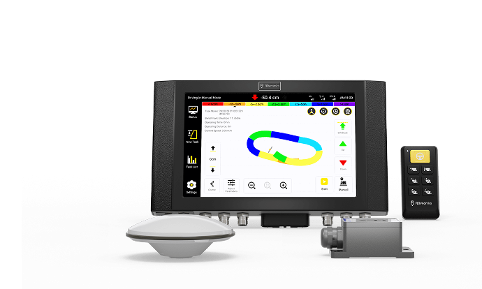
FJD AL01 3D Land Leveling System uses GNSS & RTK high-precision positioning technology to provide a comprehensive solution for farmland leveling. This GPS land leveling system can optimize water management, improve productivity, and increase yields.


FJD AL01 3D Land Leveling System uses GNSS & RTK high-precision positioning technology to provide a comprehensive solution for farmland leveling. This GPS land leveling system can optimize water management, improve productivity, and increase yields.


Application

Application

Use FJD Land Leveling System to reclaim wasteland, consolidate and level fields, convert slopes into terraces, and optimize water usage for rice paddies.

Use FJD Land Leveling System to reclaim wasteland, consolidate and level fields, convert slopes into terraces, and optimize water usage for rice paddies.

Wasteland
Reclamation

Land Consolidation
And Leveling

Conversion of Slopes
Into Terraces

Paddy Field
Work

Benefits

Benefits

 22%

Water Consumption


 10%

Fuel Consumption


 40%

Work Efficiency


 22%

Water Consumption

 10%

Fuel Consumption

 40%

Work Efficiency

Light-Load/Heavy-Load Mode Switch

Light-Load/Heavy-Load Mode Switch


Precise Leveling

The light-load mode is suitable for fine-leveling fields with small elevation differences. It consumes 10% less fuel in comparison with the heavy-load mode under the same condition. The highest speed of light-load mode: 15km/h. Leveled farmland saves up to 22% on water usage in comparison with an unleveled counterpart.


Wasteland Reclamation

The heavy-load mode levels fields with large elevation differences and works wonder at the early stage of wasteland reclamation.

GNSS-based Land Leveling System

GNSS-based Land Leveling System

Say goodbye to the laser system's troubling setup, limited signal coverage, and demanding weather conditions. Say hello to AL01, the GNSS-based land leveling system that achieves 2.5 cm accuracy  1 , increases efficiency by 40%, and covers a larger area in comparison  2  .

Say goodbye to the laser system's troubling setup, limited signal coverage, and demanding weather conditions. Say hello to AL01, the GNSS-based land leveling system that achieves 2.5 cm accuracy¹ , increases efficiency by 40%, and covers a larger area in comparison² .

1. Accuracy varies in conditions.
2. The comparison of efficiency and signal coverage takes place under the same environment and with the same machinery configuration.

Terrain Digitalization

Terrain Digitalization

Minimize land leveling costs with terrain digitalization.

Minimize land leveling costs with terrain digitalization.

Integrated Field Survey

Integrated Field Survey


Benchmark Auto-setting

Survey the field, determine the benchmark elevation, adjust the scraper, and level the farmland based on the benchmark right in the cab.


Benchmark Manual-setting 

Mannually lower the scraper blade to the desired elevation and set it as the benchmark.


Slope Benchmark Setting 

Two ways to set a benchmark for leveling an uneven slope.
1. Determine the elevations of the highest and lowest points of a slope for the system to configure a flat surface as the benchmark.
2. Determine the elevation of a point and manually increase or decrease the value to create a difference, which enables the creation of a benchmark surface.


Benchmark Auto-setting

Survey the field, determine the benchmark elevation, adjust the scraper, and level the farmland based on the benchmark right in the cab.


Benchmark Manual-setting 

Mannually lower the scraper blade to the desired elevation and set it as the benchmark.


Slope Benchmark Setting 

Two ways to set a benchmark for leveling an uneven slope.
1. Determine the elevations of the highest and lowest points of a slope for the system to configure a flat surface as the benchmark.
2. Determine the elevation of a point and manually increase or decrease the value to create a difference, which enables the creation of a benchmark surface.